Getting trained as a drone pilot is only one part of becoming a responsible professional operator.
Before every flight, a trained pilot also needs to understand where the drone can legally fly, whether permission is required and whether any temporary restriction applies to the planned location.
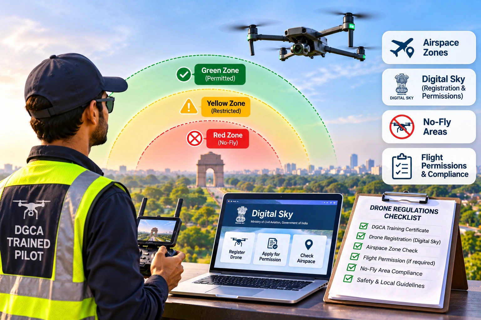
In India, drone operations are governed by the applicable aviation framework, including the Drone Rules, 2021 and subsequent amendments and regulatory directions. The Ministry of Civil Aviation states that India’s drone airspace is divided into Green, Yellow and Red Zones, with the airspace map available through the DigitalSky platform.
For a professional pilot, the basic process should be:
Check DigitalSky → Identify the Zone → Check Restrictions → Obtain Permission if Required → Complete Pre-Flight Checks → Fly Within the Applicable Rules
Understanding these steps is essential for anyone planning commercial, surveying, inspection, mapping, photography or other professional drone operations.
Why Do Drone Pilots Need to Understand Airspace Rules?
A location that appears safe from the ground may still have restrictions on drone operations.
For example, a proposed flight could be near:
- An operational airport
- Defence or military infrastructure
- Strategic installations
- Controlled airspace
- A restricted or prohibited area
- A temporary security restriction
- Another designated restricted zone
The fact that a drone is technically capable of flying somewhere does not mean that the flight is automatically permitted.
The Ministry of Civil Aviation specifically states that pilots should check the current airspace information before operating because zone boundaries and restrictions can change.
This is why airspace awareness should be treated as a core pilot skill, not an administrative formality.
What Are the Drone Airspace Zones in India?
Indian drone airspace is broadly divided into three categories:
Green Zone
Yellow Zone
Red Zone
Each zone has different operating requirements.
| Zone | General Meaning | Permission Requirement |
|---|---|---|
| Green | Permitted drone airspace subject to applicable rules | No prior airspace permission generally required |
| Yellow | Restricted airspace | Permission from the concerned air traffic control authority |
| Red | No-drone/restricted airspace | Permission from the Central Government and applicable authorities |
The exact boundaries are shown on the current DigitalSky airspace map and should always be checked before a flight.
What Is a Green Zone for Drones?
A Green Zone is airspace where drone operations can generally take place without prior airspace permission, subject to the applicable drone rules and operating conditions.
The Drone Rules define Green Zone airspace up to 400 feet or 120 metres above ground level where the area has not been designated as Red or Yellow Zone. They also provide for Green Zone airspace up to 200 feet or 60 metres in the relevant area between 8 km and 12 km from the perimeter of an operational airport.
However, Green Zone does not mean “anything goes.”
A pilot still needs to comply with applicable requirements relating to:
- Drone registration
- Type certification where applicable
- Remote Pilot Certificate requirements
- Visual Line of Sight
- Safety distances
- Weather
- Privacy
- Pre-flight checks
- Applicable operating limitations
DGCA’s current guidance specifically instructs RPC holders to check DigitalSky before every flight and maintain VLOS.
What Is a Yellow Zone for Drones?
A Yellow Zone is restricted airspace where drone operations require permission from the concerned air traffic control authority.
The Drone Rules define Yellow Zone to include, among other areas:
- Airspace above 400 feet in designated Green Zones
- Airspace above 200 feet between 8 km and 12 km from an operational airport
- Relevant airspace between 5 km and 8 km from the perimeter of an operational airport
The exact zone shown on the current airspace map should always be used for flight planning.
DGCA’s current pilot guidance states that pilots should obtain the applicable ATC/MoCA permission for Yellow/Red Zones before operating.
A common mistake is assuming that being close to an airport only matters if the drone is physically inside the airport boundary.
That is not how drone airspace planning works.
The relevant airspace restrictions can extend beyond the airport perimeter.
What Is a Red Zone for Drones?
A Red Zone is an area where drone operations are not permitted without the required permission from the Central Government.
The Drone Rules define Red Zone as designated airspace in which unmanned aircraft operations are permitted only by the Central Government.
Red Zones can cover sensitive or restricted areas designated by the relevant authorities.
The important point for pilots is:
Never assume that a Red Zone can be flown in simply because the flight is for commercial, government or emergency work.
The required permission must be obtained before operating.
The Ministry of Civil Aviation’s current Red Zone procedure requires information such as the operation location in KML format, operating-agency details, drone specifications, pilot certificates and other relevant documents. Permission becomes effective after the required NOC from the concerned Red/Yellow Zone creator agency.
What Is DigitalSky and Why Is It Important?
DigitalSky is the Government’s drone airspace information and flight-planning platform.
The Ministry of Civil Aviation describes DigitalSky as providing drone users with airspace information and flight-planning facilities, including access to the Green, Yellow and Red Zone information.
For pilots, DigitalSky is important because it helps answer one of the first questions that should be asked before every flight:
“Can I legally operate my drone at this location and altitude?”
The Ministry also states that regulatory applications under the Drone Rules have moved to the DGCA eGCA portal, while DigitalSky continues to provide airspace information and flight-planning functions.
Check the DigitalSky drone airspace information
Why Must Pilots Check DigitalSky Before Every Flight?
Airspace information is not something a pilot should check once and then rely on indefinitely.
Restrictions can change because of:
- Temporary security requirements
- Events
- Government activity
- Changes in airspace classification
- Operational airport requirements
- Law-enforcement restrictions
- Other authorised notifications
The Drone Rules specifically require pilots to verify DigitalSky for applicable restrictions before commencing an operation.
DGCA’s current guidance also states:
Always check airspace on DigitalSky before every flight.
This should become part of every professional pilot’s standard pre-flight routine.
What Are No-Fly Areas for Drones in India?
The phrase “no-fly area” is commonly used for locations where drone operations are prohibited or highly restricted.
However, pilots should avoid relying on a generic online list of locations.
The current DigitalSky map and applicable official restrictions should take priority because designated zones can be updated.
Examples of sensitive areas that may have restrictions include:
- Airport-related airspace
- Military and defence areas
- Strategic installations
- Restricted or prohibited airspace
- Government or security-sensitive locations
- Temporary Red Zones
- Other areas specifically designated by competent authorities
The earlier Indian drone regulatory framework also identified areas around airports, international borders, strategic locations and vital or military installations as sensitive locations. Current operations should nevertheless be planned using the applicable current airspace information rather than relying on older distance-based lists.
What Is a Temporary Red Zone?
A Temporary Red Zone is an important concept that professional pilots should understand.
Authorities can temporarily restrict drone operations in a particular area when there is an urgent operational, security or law-enforcement requirement.
The Drone Rules provide for temporary Red Zones, and the current regulatory framework requires pilots to verify applicable restrictions before flight.
This means a location that was available for drone operations during a previous flight may not necessarily be available today.
For this reason, professional pilots should never rely only on:
- Yesterday’s airspace screenshot
- An old flight plan
- A previous permission
- A colleague’s verbal confirmation
Always verify the current status.
Do You Need Permission to Fly a Drone in India?
It depends on the zone, drone and operation.
In general:
Green Zone
Prior airspace permission is generally not required, subject to the applicable rules and restrictions.
Yellow Zone
Permission from the concerned air traffic control authority is required.
Red Zone
Permission from the Central Government is required, along with the applicable clearance/NOC from the relevant zone-creating authority.
A pilot should therefore determine the zone before arriving at the site or starting the flight.
What Other Drone Rules Must Trained Pilots Know?
Airspace is only one part of professional drone compliance.
DGCA’s current guidance for Remote Pilot Certificate holders highlights several other requirements.
Fly the Appropriate Drone
Pilots should operate applicable DGCA type-certified and registered drones.
Hold the Applicable RPC
The pilot should hold a valid Remote Pilot Certificate for the applicable category, sub-category and class where required.
Maintain Visual Line of Sight
Professional pilots must understand the applicable VLOS requirement.
BVLOS operations should not be conducted without specific approval from the appropriate authority.
Maintain Safe Distances
Pilots need to operate safely around people and property.
Follow Weather Limitations
The drone should be operated only in weather conditions permitted by its applicable type certification and operating limitations.
Perform Pre-Flight Checks
The aircraft should be inspected according to the manufacturer’s checklist before every flight.
Maintain the Drone Properly
Maintenance should be performed according to the manufacturer’s maintenance requirements.
Respect Privacy
Professional drone operators also need to consider privacy when capturing aerial imagery.
These requirements apply even when the flight is taking place in a Green Zone.
How Should a Professional Pilot Check a Flight Location?
A simple workflow can prevent many regulatory mistakes.
Step 1: Identify the Exact Location
Confirm:
- Latitude and longitude
- Take-off location
- Operating area
- Maximum planned altitude
Step 2: Check DigitalSky
Review the current airspace map for the exact location.
Step 3: Identify the Zone
Determine whether the location falls in:
- Green
- Yellow
- Red
Step 4: Check for Temporary Restrictions
Look for any current notifications or restrictions.
Step 5: Determine Whether Permission Is Required
If the operation is in a Yellow or Red Zone, identify the appropriate permission process.
Step 6: Check the Drone and Pilot Requirements
Confirm:
- Drone registration
- Type certification where applicable
- Applicable RPC
- Insurance
- Equipment condition
Step 7: Complete the Pre-Flight Check
Only after the regulatory and operational requirements have been confirmed should the pilot proceed with the flight.
What Is the Difference Between Airspace Permission and Site Permission?
These are two different things.
Airspace permission concerns whether the aircraft can legally operate within the relevant airspace.
Site permission concerns whether you have permission from the property owner, client or other relevant authority to operate from or over a particular site.
For example, a construction site could be located in a Green Zone.
That does not automatically mean you can enter private property, operate from the site or ignore the client’s safety procedures.
Professional drone operations should therefore consider both:
Airspace Compliance + Site/Operational Permission
What Happens If a Pilot Flies in a Restricted Zone Without Permission?
Flying in a restricted zone without the required permission can create serious regulatory and safety consequences.
The current DGCA guidance explicitly states that pilots should not fly in Red or Yellow Zones without the required permission.
The Drone Rules also provide for enforcement against violations.
More importantly, an unauthorised flight near sensitive airspace can create risks for manned aviation, security operations and people on the ground.
A professional pilot should never treat a restricted-zone flight as a minor procedural violation.
If the required permission is unavailable, the flight should not proceed.
Why Is Airspace Training Important for Professional Drone Pilots?
A trained pilot should be able to make regulatory decisions before the drone takes off.
This means understanding:
- Airspace classification
- DigitalSky
- Flight permissions
- VLOS
- Restricted areas
- Temporary restrictions
- Pre-flight planning
- Emergency procedures
- Safe operating distances
DGCA’s remote-pilot training framework includes air law, airspace, meteorology, risk assessment, safety and practical flight procedures as part of professional pilot preparation.
The Ministry of Civil Aviation also states that a Remote Pilot Certificate issued by a DGCA-authorised Remote Pilot Training Organisation is the applicable certification pathway under the amended Drone Rules.
This is why professional drone training should not focus only on learning the controls.
A pilot needs to understand the regulatory environment in which those controls are being used.
Where Can You Learn Professional Drone Pilot Training in India?
SkyGlimps provides DGCA-Certified Small Category Drone Pilot Training in Kolkata for learners seeking professional drone-pilot skills.
The training covers areas such as:
- Drone regulations
- Flight fundamentals
- Weather
- Maintenance
- Risk assessment
- Safety
- Payload operations
- Simulator training
- Practical flying
- Flight assessment
For learners planning careers in surveying, inspection, mapping, infrastructure or aerial data capture, understanding airspace and regulatory requirements is an important part of becoming professionally ready.
Explore SkyGlimps DGCA-Certified Drone Training
Frequently Asked Questions
India’s drone airspace is divided into Green, Yellow and Red Zones. Green Zones generally allow operations without prior airspace permission, while Yellow and Red Zones require the applicable permissions. The exact current zone should always be checked on DigitalSky.
Generally, no prior airspace permission is required for operations in a Green Zone, but pilots must still comply with the applicable Drone Rules, DGCA requirements, aircraft limitations, safety requirements and other restrictions.
DigitalSky provides drone airspace information and flight-planning facilities, including the Green, Yellow and Red Zone map. Regulatory applications under the Drone Rules are currently handled through DGCA’s eGCA portal.
It depends on the exact location, altitude and current airspace classification. Airport-related airspace can include Yellow and Red restrictions, so pilots should check the current DigitalSky map rather than relying on a generic distance rule.
Not without the required permission. Red Zone operations require Central Government permission and the applicable clearance/NOC from the relevant zone-creating authority.
Know the Airspace Before You Fly
A professional drone pilot should never begin with:
“The weather looks good, so let’s fly.”
The first question should be:
“Is this flight legally and operationally permitted?”
That means checking:
Location → DigitalSky → Zone → Restrictions → Permissions → Pilot/Drones Requirements → Pre-Flight Checks
The drone airspace zones in India provide a framework for determining where operations can take place and what permissions may be required.
Green Zone operations may be simpler, but they are still subject to the applicable rules.
Yellow Zones require the appropriate air traffic control permission.
Red Zones require the applicable Central Government permission and other required clearances.
Most importantly, the current DigitalSky information should always take priority over old maps, screenshots, generic internet lists or assumptions based on previous flights.
For trained pilots, airspace awareness is as important as flight control.
A professional operator does not simply know how to fly a drone.
They know where they can fly, when they can fly, what permission they need and what rules must be followed before the aircraft leaves the ground.