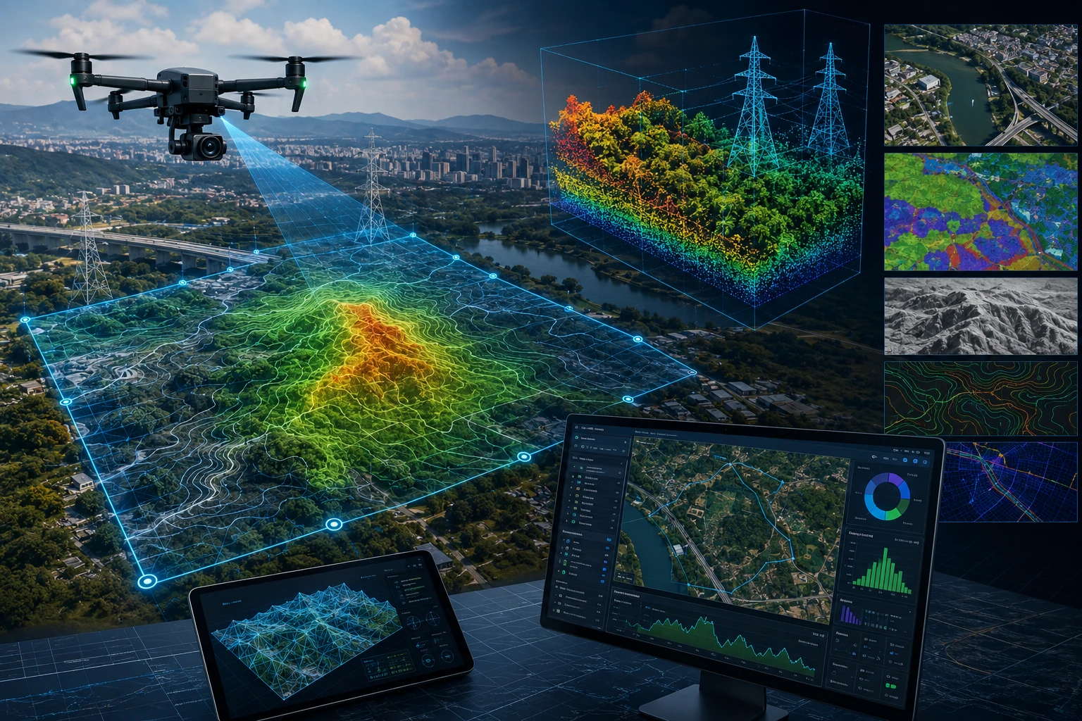
A GIS drone survey turns drone-captured aerial data into useful spatial intelligence. The drone collects images, videos, LiDAR point clouds, thermal data, or terrain information, while GIS helps organise, analyse, visualise, and share that information in a location-based system.
Without GIS, drone survey data can remain a folder of images, models, or files. With GIS, that data becomes a decision-making layer. Project teams can measure distances, compare site changes, map assets, analyse terrain, identify risks, plan maintenance, and integrate drone outputs with engineering, planning, or business workflows.
For infrastructure, mining, irrigation, urban planning, utilities, agriculture, real estate, and construction projects in India, GIS is often the difference between “drone data” and “usable project intelligence.”
What is GIS in simple terms?
GIS stands for Geographic Information System, a system used to collect, organise, manage, analyse, and display location-based data. It connects information to places on a map so users can understand patterns, relationships, and spatial decisions.
A normal spreadsheet can store data, but it may not show where that data belongs. GIS adds the “where” layer. It helps answer questions such as:
- Where is the asset located?
- Which area is affected?
- How far is one point from another?
- Which site section is low-lying?
- Where has progress changed since last month?
- Which roads, drains, towers, plots, or canals need attention?
- Which areas overlap with risk zones?
- Where should a team inspect first?
For drone survey projects, GIS gives structure to aerial data. It allows drone maps, LiDAR models, thermal findings, field points, boundaries, and project layers to be viewed together in a meaningful way.
Why is GIS important in drone survey data analysis?
GIS is important in drone survey data analysis because it converts raw aerial outputs into location-aware, measurable, and shareable project information. It helps teams move from visual review to spatial decision-making.
A drone can capture excellent data, but the value depends on how that data is processed and used. An orthomosaic map, 3D model, point cloud, or thermal image becomes more powerful when it is placed correctly in a spatial framework.
GIS helps drone survey teams:
- Organise survey data by location
- Overlay site boundaries and project layers
- Measure distance, area, and elevation
- Compare datasets across dates
- Classify assets and land features
- Connect drone outputs with field data
- Export files for engineers and planners
- Build maps and reports for stakeholders
- Support long-term asset records
For example, a drone may capture a large irrigation site. GIS can help separate canals, embankments, access roads, agricultural areas, settlements, waterlogging zones, and repair locations into structured layers. This makes the data easier to review and act upon.
For advanced spatial workflows, Skyglimps Technologies LLP provides 3D LiDAR & GIS Solutions for organisations that need drone data converted into planning-ready outputs.
What drone survey data can be analysed in GIS?
GIS can analyse many types of drone survey data, including orthomosaic maps, LiDAR point clouds, digital elevation models, contours, thermal findings, inspection images, and asset locations. The exact data depends on the project objective and sensor used.
Common GIS-ready drone outputs include:
| Drone output | What GIS helps analyse |
|---|---|
| Orthomosaic map | Site boundaries, roads, plots, land use, construction progress |
| Digital Elevation Model | Terrain, slope, drainage, low-lying zones |
| Digital Surface Model | Buildings, vegetation, structures, surface height |
| LiDAR point cloud | 3D assets, terrain, vegetation, corridor features |
| Contour map | Elevation changes and planning levels |
| Thermal inspection data | Hotspot locations and maintenance priority |
| RGB inspection images | Visible defects and asset condition |
| 3D model | Project visualisation and site review |
| GIS layers | Assets, risks, boundaries, utilities, land parcels |
Drone photogrammetry can generate orthomosaics, point clouds, DEMs, DSMs, and contour outputs. Drone LiDAR can generate dense point clouds and terrain models. Thermal inspection can generate geotagged heat-anomaly data. GIS helps organise these outputs so different teams can use them.
The main advantage is integration. GIS allows drone data to be combined with survey points, government maps, CAD drawings, BIM data, utility layers, field observations, and project records.
How does GIS help with orthomosaic drone maps?
GIS helps orthomosaic drone maps become measurable, layered, and usable for planning. An orthomosaic is a corrected top-down map created from many overlapping drone images, and GIS allows that map to be analysed with boundaries, assets, distances, areas, and other project layers.
An orthomosaic can show the full project site from above. GIS adds tools that help users measure and interpret that view.
GIS can help teams use orthomosaics to:
- Measure land area
- Review site boundaries
- Map roads and access routes
- Compare progress across dates
- Mark completed and pending work
- Identify encroachments or obstructions
- Digitise visible assets
- Overlay design drawings
- Create stakeholder maps
- Export planning-ready files
For construction projects, an orthomosaic can show whether roads, foundations, structures, and site areas are progressing. For agriculture and irrigation projects, it can show canals, fields, drains, embankments, and waterlogged areas. For urban planning, it can show roads, buildings, plots, vegetation, and public spaces.
GIS turns the orthomosaic from a static image into an analysis layer.
How does GIS improve LiDAR and point cloud analysis?
GIS improves LiDAR and point cloud analysis by helping classify, filter, measure, map, and integrate 3D spatial data with other project layers. This is important because raw point clouds are powerful but difficult to use without structure.
A LiDAR point cloud contains millions of 3D points. Each point represents a measured position on the ground, vegetation, building, road, tower, pole, embankment, or other object. GIS helps process this data into usable outputs.
GIS-supported point cloud workflows can help create:
- Digital Elevation Models
- Digital Surface Models
- Contour maps
- Cross-sections
- 3D asset layers
- Building height data
- Vegetation layers
- Road corridor models
- Utility corridor maps
- Flood-risk terrain layers
For example, in urban planning, LiDAR data can help identify building heights, road levels, drainage slopes, trees, utilities, and terrain variations. In mining, it can support terrain and volume analysis. In water-resource projects, it can support embankment, floodplain, and drainage modelling.
Skyglimps Technologies, a DGCA-certified RPTO in Kolkata, supports drone-enabled spatial workflows where LiDAR and GIS data can help project teams analyse complex sites across Eastern India.
How does GIS help compare project progress over time?
GIS helps compare project progress over time by aligning drone datasets from different dates in the same spatial framework. This allows teams to see what changed, where it changed, and how much progress has been made.
Drone surveys are especially useful when repeated. A construction project may be mapped monthly. A mining site may be surveyed after each production cycle. An embankment may be inspected before and after monsoon. A road project may be mapped at each milestone.
GIS can compare:
- Earlier and current orthomosaics
- Previous and latest elevation models
- Before-after site conditions
- Stockpile changes
- Excavation progress
- Road alignment progress
- Completed and pending zones
- Erosion or flood damage
- Asset condition changes
This gives project managers a more reliable record than scattered ground photos. It also helps reduce confusion between contractors, engineers, management teams, and clients.
For recurring visual records, teams can also use documentation and progress tracking to maintain a structured project history.
How is GIS used in infrastructure and construction projects?
GIS is used in infrastructure and construction projects to map site conditions, track progress, analyse terrain, manage assets, and support coordination between engineering and management teams. It helps connect aerial survey outputs with practical project decisions.
Infrastructure projects often involve large sites, multiple contractors, changing work fronts, and repeated reporting. GIS helps organise the site into layers that different teams can understand.
GIS drone survey analysis can support:
- Road and corridor mapping
- Bridge and flyover documentation
- Construction progress tracking
- Earthwork and terrain review
- Utility corridor mapping
- Site access planning
- Drainage and slope analysis
- Asset inventory creation
- Contractor progress verification
- Stakeholder reporting
For example, a road project may use drone data to map alignment, access points, drainage areas, structures, and work progress. GIS can organise each of these into separate layers so project teams can review the road corridor more clearly.
For planning authorities, consultants, and developers, drone and GIS data can also support urban planning and smart city projects where spatial clarity is essential.
How does GIS support inspection and maintenance workflows?
GIS supports inspection and maintenance workflows by linking each defect, hotspot, asset, or observation to a location on the map. This helps maintenance teams find, prioritise, and track issues more effectively.
Drone inspections may capture thousands of images. Without GIS, those images can be hard to organise. GIS helps connect each image or finding to a location, asset ID, tower number, panel row, structure, or project zone.
GIS can support maintenance for:
- Power lines and towers
- Solar farms
- Industrial assets
- Roofs and buildings
- Roads and bridges
- Pipelines and corridors
- Irrigation canals
- Embankments
- Mining sites
- Public infrastructure
For thermal inspections, GIS can map hotspot locations. For RGB inspections, it can locate visible defects. For repeat inspections, it can show whether the same issue is stable, repaired, or worsening.
Skyglimps Technologies LLP provides Thermal & RGB Inspections for organisations that need aerial inspection data that can support maintenance and asset review.
How does GIS help decision-makers use drone data?
GIS helps decision-makers use drone data by presenting technical survey information in a clear map-based format. Instead of reviewing disconnected files, stakeholders can understand the project through layers, locations, measurements, and visual evidence.
Decision-makers often do not need raw files. They need answers:
- Which area needs repair?
- Which section is delayed?
- Where is the flood risk?
- Which asset is damaged?
- What has changed since the last survey?
- Which contractor zone is pending?
- Where should field teams go first?
- What evidence supports the decision?
GIS helps convert drone data into these answers. It creates maps, dashboards, reports, and spatial layers that can be shared with project teams, government departments, engineers, consultants, and management.
A good GIS workflow reduces information overload. It turns technical drone outputs into decision-ready views.
What deliverables should a GIS drone survey include?
A GIS drone survey should include deliverables that match the client’s decision-making needs, such as orthomosaics, DEMs, DSMs, contours, point clouds, GIS layers, asset maps, and reports. The format should be agreed before the survey starts.
Common deliverables include:
| Deliverable | Best use |
| Orthomosaic map | Top-down site view and measurement |
| DEM | Bare-earth terrain and drainage analysis |
| DSM | Surface height and built environment review |
| Contour map | Elevation planning |
| Point cloud | 3D spatial analysis |
| GIS layers | Project mapping and decision workflows |
| Asset map | Maintenance and inventory planning |
| Thermal hotspot layer | Inspection prioritisation |
| Progress map | Construction or project tracking |
| PDF report | Management and stakeholder review |
| CAD/GIS files | Technical team integration |
Not every project needs every deliverable. A construction client may need orthomosaics and progress maps. A water-resources team may need DEMs, contours, and flood-risk layers. A utility client may need asset maps and inspection findings. A smart city team may need GIS layers and 3D models.
The best approach is to define the decision first, then choose the deliverable.
How should businesses plan a GIS drone survey project?
Businesses should plan a GIS drone survey project by defining the project objective, site boundary, required accuracy, deliverables, file formats, coordinate system, and end users before the drone flight. This helps ensure the data is usable after delivery.
Before starting, answer these questions:
- What decision should the drone survey support?
- What is the site boundary?
- What accuracy level is required?
- Are ground control points needed?
- Which outputs are required?
- Will the data be used in GIS, CAD, BIM, or reports?
- Which file formats are needed?
- What coordinate system should be used?
- Who will use the data after delivery?
- Is repeat monitoring required?
- Are airspace or site permissions needed?
- How will the data be stored and shared?
A drone survey should not begin with only “fly the site.” It should begin with the final use of the data. GIS makes that final use clearer by connecting the survey plan to the decision-making workflow.
Why choose Skyglimps Technologies for GIS drone survey workflows?
Skyglimps Technologies LLP is a Kolkata-based drone services company and DGCA-certified Remote Pilot Training Organisation serving government and enterprise clients across Eastern India. The company supports drone-enabled workflows across LiDAR, GIS, mapping, inspections, surveillance, documentation, and training.
For organisations in Kolkata, West Bengal, and Eastern India, local understanding can improve site scoping, field execution, stakeholder communication, and repeat monitoring. GIS drone survey workflows are especially useful when a project involves terrain, assets, infrastructure, water resources, urban planning, mining, utilities, or construction progress.
A professional drone survey partner should help clients move beyond raw data. The goal is not just to capture aerial images; the goal is to deliver spatial information that improves decisions.
FAQ: GIS Drone Survey
GIS in drone survey means using Geographic Information Systems to organise, analyse, map, and share drone-captured data such as orthomosaics, point clouds, DEMs, contours, and inspection findings.
GIS is important because it turns raw drone outputs into location-based project information. It helps teams measure, compare, classify, overlay, and analyse survey data.
GIS can use orthomosaic maps, DEMs, DSMs, contour maps, LiDAR point clouds, RGB inspection images, thermal findings, asset locations, and project boundaries.
No. Simple aerial photos may not need GIS. But mapping, surveying, infrastructure, inspection, terrain, asset, and planning projects benefit strongly from GIS analysis.
Yes. GIS can align drone surveys from different dates to compare progress, terrain changes, damage, repair work, stockpiles, and site development.
Common formats may include GeoTIFF, SHP, KML, DXF, LAS/LAZ, CSV, PDF, and CAD/GIS-compatible outputs depending on project requirements.
GIS drone survey data is used by engineers, planners, surveyors, contractors, mining teams, utility companies, irrigation departments, smart city teams, and project managers.
Turn drone data into project intelligence with GIS
A GIS drone survey helps organisations convert aerial data into useful spatial intelligence. It connects maps, models, point clouds, inspection findings, terrain data, and project layers so teams can make better decisions.
For infrastructure, construction, mining, irrigation, power utilities, urban planning, agriculture, and enterprise projects, GIS makes drone data easier to analyse, compare, and share.
If your organisation needs GIS-ready drone survey outputs, LiDAR point clouds, terrain models, asset maps, or spatial analysis in Kolkata, West Bengal, or Eastern India, connect with Skyglimps Technologies LLP through the 3D LiDAR & GIS Solutions service page and share your project location, objective, and required deliverables.