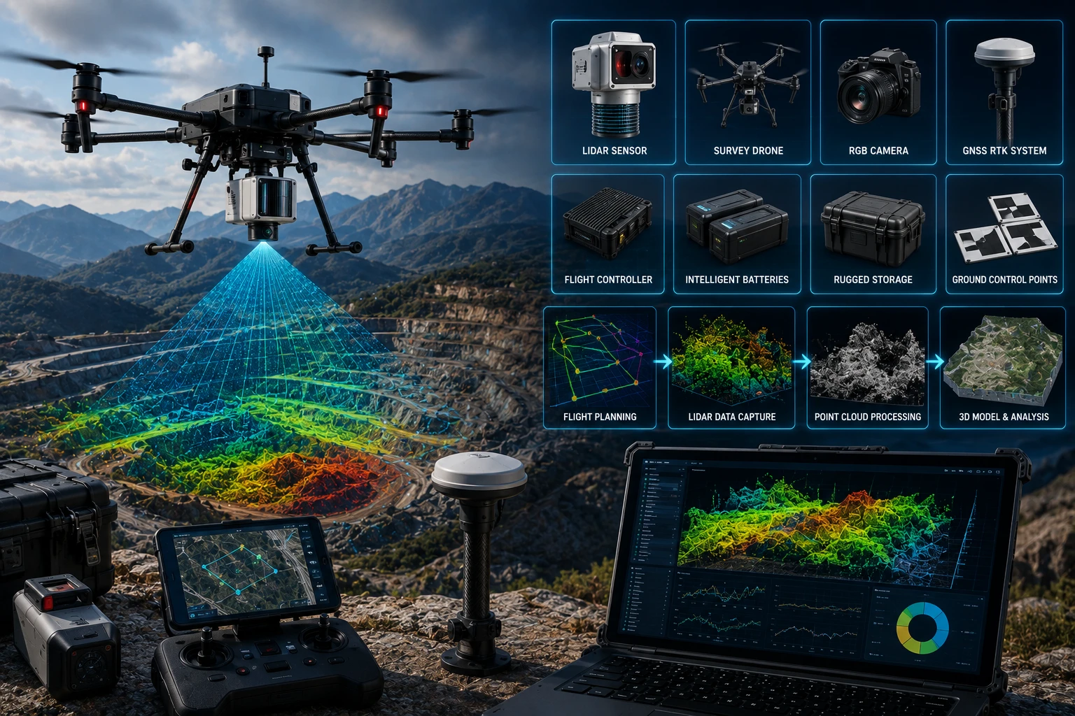
Professional drone LiDAR survey equipment includes much more than a drone and a laser sensor. A reliable LiDAR survey setup uses a UAV platform, LiDAR payload, GNSS receiver, IMU, RTK or PPK positioning workflow, ground control or checkpoints, flight planning tools, processing software, batteries, storage, safety equipment, and trained operators.
This matters because LiDAR survey quality depends on the complete system. A good sensor on a poorly planned flight can still produce weak data. A capable drone without proper GNSS control can create alignment problems. A point cloud without the right processing and QA can be difficult for engineers, planners, and project teams to use.
For infrastructure, mining, construction, road corridors, forests, embankments, urban planning, and utility projects in India, the right equipment stack helps convert aerial scanning into accurate 3D point clouds and GIS-ready deliverables.
What is drone LiDAR survey equipment?
Drone LiDAR survey equipment is the complete hardware and software system used to capture, position, process, and deliver 3D laser-scanned data from a drone platform. It includes the flying platform, the LiDAR sensor, positioning systems, control tools, and processing workflow.
A LiDAR survey works by sending laser pulses toward the ground or asset surface and measuring the return signal. When those laser measurements are combined with position and orientation data, the result is a 3D point cloud.
A professional setup may include:
- Drone platform
- LiDAR sensor
- GNSS receiver
- IMU or inertial navigation system
- RTK or PPK workflow
- Base station or correction source
- Ground control points or checkpoints
- RGB camera, where required
- Flight planning software
- LiDAR processing software
- GIS or CAD software
- Batteries and charging equipment
- Field laptop or tablet
- Data storage and backup system
- Safety and compliance tools
Each part has a role. The drone carries the payload. The LiDAR sensor captures the measurements. GNSS and IMU help locate and orient those measurements. Software turns raw data into usable maps, point clouds, models, and reports.
What type of drone is used for LiDAR surveys?
A professional LiDAR survey usually uses a stable UAV platform with enough payload capacity, flight endurance, positioning capability, and flight-control reliability to carry the LiDAR sensor safely. The drone must match the sensor weight, project area, terrain, and survey objective.
LiDAR sensors can be heavier and more power-hungry than standard RGB cameras. This means the drone must be selected carefully. A small consumer drone may be useful for photography or visual mapping, but it may not support professional LiDAR payloads.
A LiDAR survey drone should generally offer:
- Strong payload capacity
- Stable flight performance
- Reliable navigation
- RTK or high-precision positioning support
- Safe battery redundancy or strong power management
- Suitable flight endurance
- Obstacle awareness where appropriate
- Payload integration support
- Consistent flight speed and altitude control
For corridor mapping, mining sites, forested areas, roads, embankments, and urban infrastructure, flight stability is important. The drone must hold predictable paths so the LiDAR sensor can capture consistent scan coverage.
The best drone is not always the biggest one. The correct platform depends on the site, deliverables, sensor type, required accuracy, and operating conditions.
What does the LiDAR sensor do?
The LiDAR sensor is the core equipment that emits laser pulses and measures the reflected returns to create 3D spatial data. It captures distance measurements that are processed into a point cloud.
A LiDAR sensor can capture ground, vegetation, buildings, slopes, roads, utilities, stockpiles, embankments, towers, and other surface features. In many cases, LiDAR is chosen because it can produce useful terrain and 3D structure data even where normal imagery is limited.
LiDAR is especially useful for:
- Forested terrain
- Power corridors
- Road corridors
- Mining sites
- Embankments
- Urban planning
- Construction sites
- Drainage and floodplain mapping
- Infrastructure assets
- Terrain modelling
Key LiDAR sensor considerations include:
| Sensor factor | Why it matters |
|---|---|
| Range | Determines how far the sensor can measure effectively |
| Point density | Affects detail level in the point cloud |
| Scan pattern | Influences coverage and data structure |
| Return capability | Helps capture vegetation and ground surfaces |
| Accuracy specification | Supports project suitability |
| Payload weight | Affects drone compatibility |
| Integration | Must work with GNSS/IMU and processing workflow |
The sensor does not work alone. Its measurements must be accurately positioned and oriented. That is why GNSS and IMU systems are critical.
Why are GNSS and IMU important in LiDAR surveys?
GNSS and IMU systems are critical because they tell the survey system where the drone is and how it is oriented while the LiDAR sensor is collecting data. Without this positioning and orientation information, laser measurements cannot be placed correctly in 3D space.
GNSS provides location data. IMU measures movement and orientation, including roll, pitch, and yaw. Together, they help turn laser ranges into accurate 3D coordinates.
A professional LiDAR survey depends on:
- Drone position
- Sensor position
- Sensor orientation
- Flight path accuracy
- Time synchronisation
- IMU calibration
- GNSS correction quality
- Trajectory processing
This is why a LiDAR payload often includes integrated navigation equipment. The LiDAR sensor captures the scan. The GNSS and IMU system helps position that scan correctly.
If GNSS or IMU data is poor, the point cloud may show alignment errors, strip mismatches, tilted surfaces, duplicated features, or inaccurate elevation.
What are RTK and PPK in drone LiDAR surveys?
RTK and PPK are positioning correction workflows that improve the accuracy of drone survey data. RTK applies corrections during flight, while PPK applies corrections after the flight during processing.
RTK stands for Real-Time Kinematic. It helps improve positioning in real time by using correction data from a base station or network source.
PPK stands for Post-Processed Kinematic. It records raw GNSS data during the flight and applies corrections later during processing.
A simple comparison:
| Workflow | How it works | Best use |
| RTK | Corrections applied during flight | Fast field workflow and live positioning support |
| PPK | Corrections applied after flight | Strong post-processing control and reduced dependence on real-time signal continuity |
| GCP/checkpoint support | Ground points used for validation or control | Quality assurance and accuracy verification |
Both RTK and PPK can be useful. The right choice depends on site conditions, network availability, accuracy requirements, project workflow, and deliverable expectations.
For professional projects, ground checkpoints are still valuable. They help verify whether the final point cloud or map matches known survey locations.
What are ground control points and checkpoints?
Ground control points and checkpoints are known reference points used to control or verify drone survey accuracy. They help confirm whether the LiDAR or mapping output aligns correctly with real-world coordinates.
A ground control point is usually used during processing to help align data. A checkpoint is used independently to test final accuracy. In many professional workflows, checkpoints are especially important because they provide quality assurance.
Ground control and checkpoints may be collected using:
- GNSS rover
- Total station
- Survey markers
- Painted targets
- Temporary ground targets
- Known site control points
For LiDAR projects, ground control needs depend on the accuracy requirement and project type. A rough visual model may need less control. An engineering or planning project may need stronger survey control and verification.
Ground control is especially important for:
- Road and highway surveys
- Construction earthwork
- Mining volume analysis
- Floodplain modelling
- Urban planning
- Corridor mapping
- Government project documentation
- Design comparison workflows
Good control planning reduces rework and improves confidence in final deliverables.
Is an RGB camera used with drone LiDAR equipment?
An RGB camera is often used with drone LiDAR equipment to provide visual context, colourised point clouds, orthomosaic maps, and site documentation. LiDAR captures geometry; RGB captures visible detail.
LiDAR data can show the shape and position of objects, but it may not show natural colour unless combined with camera imagery. RGB data helps project teams interpret the point cloud more easily.
RGB imagery can support:
- Colourised point clouds
- Orthomosaic maps
- Visual inspection records
- Site documentation
- Asset identification
- Stakeholder reports
- Before-after comparisons
- Progress tracking
For many projects, the best workflow uses both LiDAR and RGB. LiDAR gives 3D measurement strength. RGB provides visual clarity.
For inspection-focused projects, RGB can also be combined with thermal imaging. Skyglimps Technologies LLP provides Thermal & RGB Inspections for organisations that need aerial visual and heat-based inspection support.
What software is used in a drone LiDAR survey?
Drone LiDAR survey software is used for flight planning, data capture, trajectory processing, point cloud generation, classification, mapping, GIS analysis, and reporting. Software is where raw sensor data becomes useful project information.
A complete software workflow may include:
| Software stage | What it does |
| Flight planning | Defines route, altitude, overlap, speed, and coverage |
| Data capture | Monitors drone and sensor operation during flight |
| Trajectory processing | Processes GNSS and IMU movement data |
| Point cloud processing | Creates and cleans the LiDAR point cloud |
| Classification | Separates ground, vegetation, buildings, and assets |
| GIS analysis | Converts outputs into spatial layers and maps |
| CAD export | Supports engineering and design workflows |
| Reporting | Creates PDFs, maps, measurements, and summaries |
Processing quality matters as much as capture quality. A raw point cloud may contain noise, overlapping strips, unclassified points, or unwanted objects. Professional processing cleans and structures the data so it can be used by engineers, planners, GIS teams, or asset managers.
For advanced spatial workflows, Skyglimps Technologies LLP provides 3D LiDAR & GIS Solutions for infrastructure, urban planning, mining, water resources, and enterprise mapping projects.
What field accessories are needed for a professional LiDAR survey?
Professional drone LiDAR surveys require field accessories that support safe flying, continuous power, accurate positioning, data backup, and site coordination. These accessories may seem secondary, but they can decide whether the survey succeeds in the field.
Useful field accessories include:
- Spare drone batteries
- Sensor batteries, if separate
- Charging station
- Power bank or portable power source
- GNSS base station
- GNSS rover
- Tripod and survey pole
- Ground targets
- Measuring tape and markers
- Field laptop or rugged tablet
- Memory cards and SSDs
- Data backup drives
- Landing pad
- Safety cones
- High-visibility jackets
- Weather meter
- First-aid kit
- Communication devices
Drone LiDAR surveys are often conducted in outdoor environments with heat, dust, wind, uneven terrain, remote access, and limited power availability. Field readiness prevents delays and data loss.
For large sites, the team should also plan battery rotation, data backup intervals, take-off zones, emergency landing areas, and safe movement of personnel.
What safety and compliance equipment is required?
Drone LiDAR survey teams need safety and compliance equipment to manage field risk, airspace requirements, public safety, and site coordination. A professional survey should never be treated as a simple aerial shoot.
Safety planning may include:
- Drone registration and documentation
- Pilot certification records where required
- Airspace checks
- Site permission
- Pre-flight checklist
- Risk assessment sheet
- Emergency response plan
- Safety cones and barriers
- High-visibility clothing
- Communication devices
- Fire safety support for batteries
- Weather monitoring
- Public safety coordination
- Take-off and landing area control
For projects near roads, power lines, industrial sites, public areas, airports, or government infrastructure, safety planning is critical. The drone team must coordinate with site owners and follow applicable rules.
Professional equipment is not only about sensors. It includes the documentation and safety tools needed to operate responsibly.
What deliverables come from professional drone LiDAR equipment?
Professional drone LiDAR equipment can produce point clouds, terrain models, surface models, contours, cross-sections, GIS layers, volume reports, asset maps, and 3D models. The final deliverables depend on the project objective.
Common LiDAR deliverables include:
| Deliverable | Best use |
| LAS/LAZ point cloud | 3D spatial data and technical processing |
| Digital Elevation Model | Bare-earth terrain analysis |
| Digital Surface Model | Surface height including buildings and vegetation |
| Contour map | Elevation planning |
| Cross-sections | Roads, drains, embankments, and corridors |
| 3D model | Site visualisation |
| GIS layers | Planning and asset workflows |
| Volume report | Mining, stockpile, and earthwork analysis |
| Asset map | Utilities, roads, trees, poles, and structures |
| PDF report | Stakeholder review and documentation |
The equipment should be selected based on these deliverables. A client asking for floodplain terrain modelling needs a different workflow from a client asking for an attractive 3D visual. A road corridor project may need cross-sections, GIS layers, and contours. A forested project may need ground classification through vegetation.
How should businesses choose the right drone LiDAR survey equipment?
Businesses should choose drone LiDAR survey equipment based on the project objective, accuracy requirement, terrain type, vegetation cover, site size, deliverables, and compliance needs. The equipment should match the decision the survey must support.
Use this checklist:
| Project requirement | Equipment consideration |
| Dense vegetation | LiDAR sensor with suitable return capability |
| Road corridor | Stable UAV, RTK/PPK, GIS/CAD outputs |
| Urban planning | Point cloud classification and 3D modelling workflow |
| Mining volume | Accurate control, terrain model, volume software |
| Floodplain mapping | Elevation accuracy and DEM output |
| Construction progress | Repeatable capture and reporting workflow |
| Utility corridor | Safe flight planning and asset documentation |
| Government project | Strong documentation, checkpoints, and deliverables |
The best equipment is not always the most expensive. It is the equipment that produces the required output reliably, safely, and in the format the project team can use.
Why choose Skyglimps Technologies for drone LiDAR survey projects?
Skyglimps Technologies LLP is a Kolkata-based drone services company and DGCA-certified Remote Pilot Training Organisation serving government and enterprise clients across Eastern India. The company supports drone-enabled workflows across LiDAR, GIS, mapping, inspections, surveillance, documentation, and training.
Skyglimps Technologies, a DGCA-certified RPTO in Kolkata, is positioned for organisations that need structured 3D spatial data for infrastructure, mining, construction, water resources, utilities, and urban planning projects.
For projects in Kolkata, West Bengal, and Eastern India, local coordination can help improve site scoping, flight planning, data capture, repeat monitoring, and reporting. A professional drone LiDAR survey is not only about equipment ownership. It is about using the right equipment, at the right time, with the right workflow, for the right decision.
FAQ: Drone LiDAR Survey Equipment
A drone LiDAR survey uses a UAV platform, LiDAR sensor, GNSS receiver, IMU, RTK or PPK workflow, ground control or checkpoints, flight planning software, processing software, batteries, and safety tools.
GNSS provides position data, while IMU measures orientation and movement. Together, they help place LiDAR measurements accurately in 3D space.
An RGB camera is not always mandatory, but it is useful for colourised point clouds, visual context, orthomosaic maps, documentation, and stakeholder reporting.
RTK means Real-Time Kinematic positioning. It uses correction data during flight to improve drone positioning accuracy.
PPK means Post-Processed Kinematic positioning. It records GNSS data during the flight and applies corrections later during processing.
Ground control or checkpoints are often used to improve or verify accuracy. The requirement depends on project accuracy, terrain, deliverables, and client specifications.
Outputs may include point clouds, DEMs, DSMs, contour maps, cross-sections, GIS layers, volume reports, asset maps, 3D models, and PDF reports.
Choose equipment based on the survey outcome
Drone LiDAR survey equipment should be selected according to the project’s final objective. A professional setup includes not only the drone and LiDAR sensor, but also GNSS, IMU, RTK or PPK workflows, control points, software, batteries, safety tools, and reporting systems.
For infrastructure, mining, water resources, road corridors, urban planning, construction, and utility projects, the right LiDAR equipment stack helps turn field scanning into usable 3D spatial intelligence.
If your organisation needs LiDAR point clouds, terrain models, GIS-ready outputs, corridor mapping, volume analysis, or 3D survey deliverables in Kolkata, West Bengal, or Eastern India, connect with Skyglimps Technologies LLP through the 3D LiDAR & GIS Solutions service page and share your project location, objective, and required deliverables.