A drone survey road highway workflow helps government agencies, infrastructure departments, contractors, consultants, and project monitoring teams capture accurate aerial data for road planning, construction tracking, asset inspection, and maintenance documentation. Instead of depending only on manual site visits, ground photos, or delayed progress reports, drone surveys provide a clearer view of road and highway projects from above.
For government road projects in India, visibility is critical. Highways, bridges, bypasses, rural roads, urban corridors, and expressway sections involve land, drainage, earthwork, utilities, structures, traffic movement, safety risks, and multiple stakeholders. Drone surveys make it easier to document current site conditions, track progress, review work quality, and maintain project records.
This guide explains what government agencies need to know before using drone surveys for road and highway projects.
What is a drone survey for road and highway projects?
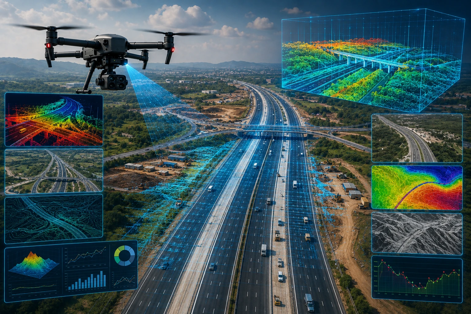
A drone survey for road and highway projects is the use of drones to capture aerial images, maps, videos, terrain data, and site documentation across road corridors. The data can be processed into orthomosaic maps, progress reports, 3D models, contour maps, GIS layers, and inspection records.
A road or highway drone survey can cover:
- Proposed road alignments
- Existing highways
- Road widening projects
- Bypass roads
- Bridges and flyovers
- Culverts and drainage structures
- Earthwork zones
- Construction progress
- Roadside encroachments
- Median and shoulder areas
- Junctions and toll plaza areas
- Service roads and access roads
- Maintenance-priority sections
For government agencies, the biggest advantage is structured visibility. A drone survey can show the entire road corridor in a way that is easier to review, compare, and share with project teams.
Skyglimps Technologies LLP provides 2D Surveying & Mapping for organisations that need aerial mapping and site documentation for infrastructure, road, land, and development projects.
Why are drones useful for government road agencies?
Drones are useful for government road agencies because they improve transparency, monitoring, documentation, and decision-making across the project lifecycle. They help officials and consultants see what is happening on-site without depending only on selective field updates.
Road and highway projects are spread over long distances. A single project may pass through villages, agricultural land, urban edges, bridges, drainage crossings, utility corridors, and difficult terrain. Manual review of every section can take time and may not produce consistent documentation.
Drone surveys help government teams:
- Review long road stretches faster
- Document project progress at regular intervals
- Compare planned and actual work
- Identify visible site constraints
- Track earthwork and alignment progress
- Review access roads and construction staging
- Inspect bridges, culverts, and drainage structures
- Maintain visual records for reporting
- Support contractor coordination
- Improve stakeholder communication
Drones do not replace engineering supervision or technical quality checks. They support those processes with better visual and spatial evidence.
Where can drone surveys be used in a road project lifecycle?
Drone surveys can be used during planning, DPR support, pre-construction documentation, construction monitoring, quality review, completion records, and operation-and-maintenance stages. The survey objective changes at each stage.
A practical road project lifecycle looks like this:
| Project stage | How drone survey helps |
|---|---|
| Planning | Captures current site condition and corridor context |
| DPR support | Provides aerial base data and alignment visibility |
| Pre-construction | Documents original ground condition before work begins |
| Construction | Tracks earthwork, structures, drainage, and road progress |
| Contractor review | Compares work completed across sections |
| Completion | Creates final visual records of the completed stretch |
| Maintenance | Supports road condition, encroachment, drainage, and asset review |
| Dispute review | Provides dated visual evidence of site status |
For government projects, dated drone records can become especially useful. They help show what existed before work, what changed during execution, and what was completed at each stage.
What deliverables should agencies expect from a drone survey road highway project?
Government agencies should expect clear deliverables such as aerial images, orthomosaic maps, videos, progress reports, GIS files, 3D models, and corridor documentation. The deliverables should be defined before the drone flight begins.
Common deliverables include:
| Deliverable | Best use |
| Aerial images | Visual site documentation |
| Drone video | Corridor overview and progress review |
| Orthomosaic map | Accurate top-down road corridor view |
| 2D map | Planning, measurement, and reporting |
| Contour map | Elevation and slope review |
| Digital Elevation Model | Terrain and drainage planning |
| 3D model | Corridor and structure visualisation |
| GIS layers | Government mapping and planning workflows |
| Progress report | Contractor and milestone review |
| Before-after comparison | Change tracking and completion records |
A folder of drone photos is not enough for serious project use. The survey should produce structured outputs that can be reviewed by engineers, project directors, consultants, contractors, and government stakeholders.
For projects requiring 3D terrain, detailed corridor modelling, or advanced spatial outputs, Skyglimps also provides 3D LiDAR & GIS Solutions for infrastructure and planning teams.
How do drones improve road construction monitoring?
Drones improve road construction monitoring by capturing dated aerial records of work progress across the corridor. This helps agencies see which sections are completed, delayed, blocked, or ready for the next stage.
Road construction involves multiple work components, including clearing, earthwork, subgrade preparation, drainage, culverts, bridges, shoulders, medians, pavement layers, signage, and road furniture. Drone surveys help show how these components are progressing across the site.
Drone monitoring can track:
- Site clearance
- Earthwork progress
- Embankment formation
- Road alignment development
- Drainage and culvert work
- Bridge and flyover progress
- Service road construction
- Median and shoulder work
- Material storage areas
- Completed and pending stretches
- Access and traffic diversion conditions
For recurring project monitoring, drone-based documentation and progress tracking can help agencies maintain stage-wise records for review meetings, contractor coordination, and stakeholder reporting.
The strongest monitoring workflow uses repeated drone surveys at defined intervals. This creates a visual timeline of how the road project is moving.
How can drone data support DPR and planning work?
Drone data can support DPR and planning work by giving planners a current view of land conditions, road alignment, terrain, drainage, settlements, utilities, structures, and visible constraints. This helps teams understand ground reality before finalising designs or project decisions.
Aerial data can help planning teams review:
- Existing road condition
- Proposed alignment context
- Land-use patterns
- Water bodies and drains
- Utility crossings
- Nearby settlements
- Access points
- Construction constraints
- Vegetation and tree cover
- Low-lying zones
- Bridge and culvert locations
- Possible diversion routes
Drone surveys do not replace detailed engineering surveys, traffic studies, geotechnical investigations, or statutory approvals. They add a strong visual and spatial layer to planning.
For government agencies, this can reduce uncertainty during early project review. A map, orthomosaic, or drone corridor video can make the site easier to understand than scattered ground photos alone.
How do drone surveys help with drainage, culverts, and flood-prone road sections?
Drone surveys help road agencies review drainage paths, culverts, waterlogging zones, embankments, low-lying areas, and flood-prone road sections from above. This is important because drainage failure can damage roads and disrupt traffic.
Road infrastructure is directly affected by water movement. Poor drainage can cause pavement damage, erosion, shoulder failure, embankment instability, and local flooding.
Drone surveys can help identify:
- Blocked drainage channels
- Culvert entry and exit conditions
- Waterlogged shoulders
- Low-lying road sections
- Embankment erosion
- Damaged side drains
- Floodplain crossings
- River or canal-adjacent sections
- Slope and runoff patterns
- Access issues during monsoon
For road projects in Eastern India, monsoon rainfall, river systems, canals, and low-lying terrain make drainage visibility important. Drone data can support better planning before and after heavy rainfall.
For projects where road corridors interact with canals, embankments, rivers, and flood-prone areas, drone data can also support irrigation and water resources workflows.
How can drones support highway asset inspection and maintenance?
Drones support highway asset inspection by capturing visual records of roads, bridges, flyovers, culverts, toll plazas, slopes, signboards, medians, service roads, and roadside assets. This helps maintenance teams identify visible issues and prioritise field verification.
Highway maintenance requires regular asset visibility. Agencies may need to review damaged sections, encroachments, drainage issues, vegetation growth, road furniture, traffic barriers, and structure conditions.
Drone inspection can support review of:
- Pavement surface condition from above
- Roadside encroachments
- Service road condition
- Median and shoulder areas
- Bridge and flyover surroundings
- Culvert blockages
- Slope erosion
- Roadside drainage
- Toll plaza layout
- Accident-prone access points
- Utility crossings
- Construction debris or obstructions
Drone data should be combined with ground inspection, pavement testing, engineering review, and road safety audits where required. The drone provides aerial visibility; technical teams decide the corrective action.
What compliance and safety points should agencies consider?
Government agencies should ensure drone surveys are conducted by trained, compliant teams with proper airspace checks, site coordination, safety planning, and documentation. Road and highway corridors can be sensitive operating environments.
Before any drone operation, the survey team should check:
- Drone category and registration status
- Pilot certification requirements
- Airspace zone
- Site permissions
- Nearby airports or restricted areas
- Public safety risks
- Traffic movement
- Power lines and obstacles
- Weather conditions
- Safe take-off and landing areas
- Data security and confidentiality
- Emergency procedures
A registered drone and trained pilot do not automatically mean a drone can fly anywhere. Airspace, local site restrictions, road safety, public movement, and project-specific permissions must be reviewed before flight.
For government road projects, data handling is also important. Images, videos, GIS files, and corridor records should be stored and shared responsibly, especially when projects involve strategic infrastructure.
How should agencies choose a drone survey partner for road projects?
Government agencies should choose a drone survey partner by checking mapping capability, regulatory compliance, infrastructure experience, deliverable quality, GIS readiness, reporting format, and safety process. The right partner should understand road project requirements, not only drone flying.
Ask these questions before finalising a drone survey partner:
- Have you handled road, corridor, or infrastructure mapping before?
- Can you provide orthomosaic maps and GIS-ready outputs?
- Can you repeat surveys for progress comparison?
- What accuracy level can you support?
- Do you use ground control where required?
- What file formats will be delivered?
- Can you provide dated progress reports?
- How do you plan safe flights along roads?
- How do you manage data storage and confidentiality?
- Can you support 2D, 3D, and inspection deliverables?
A good drone partner will first ask about the agency’s decision-making need. A DPR support survey, construction progress survey, and maintenance inspection survey require different workflows.
Why choose Skyglimps Technologies for road and highway drone surveys?
Skyglimps Technologies LLP is a Kolkata-based drone services company and DGCA-certified Remote Pilot Training Organisation serving government and enterprise clients across Eastern India. The company supports drone workflows across surveying, mapping, LiDAR, GIS, inspections, documentation, surveillance, and training.
Skyglimps Technologies, a DGCA-certified RPTO in Kolkata, is positioned for agencies, consultants, contractors, and infrastructure teams that need structured aerial data for roads, highways, bridges, drainage corridors, and development projects.
For road and highway projects in Kolkata, West Bengal, and Eastern India, local coordination can help improve route planning, field execution, stakeholder communication, and repeat monitoring.
A drone survey road highway workflow is most valuable when the data is captured with the final decision in mind: planning, progress review, maintenance, inspection, or official documentation.
FAQ: Drone Survey Road Highway
A drone survey for road and highway projects uses drones to capture aerial images, maps, videos, terrain data, and site documentation for planning, construction monitoring, and maintenance.
Drones help agencies monitor progress, document project stages, review road corridors, identify visible constraints, inspect assets, and create clearer records for decision-making.
Yes. Drone surveys can support DPR work by providing current aerial views, corridor context, terrain information, drainage visibility, and site documentation. They do not replace all engineering studies.
Deliverables may include aerial images, drone videos, orthomosaic maps, contour maps, elevation models, 3D models, GIS layers, progress reports, and before-after comparisons.
Yes. Drones can visually document bridges, culverts, drainage structures, slopes, access conditions, and surrounding areas. Engineering verification may still be required for technical conclusions.
Yes. Drones can support maintenance by documenting visible road condition, encroachments, drainage issues, shoulder damage, vegetation, roadside assets, and access constraints.
Agencies should check drone compliance, pilot certification, airspace rules, site permission, safety planning, data handling, deliverables, and reporting format before starting a drone survey.
Build better road projects with aerial survey data
A drone survey road highway workflow helps government agencies and infrastructure teams improve project visibility, documentation, monitoring, and maintenance planning. It gives decision-makers a clearer view of road corridors, construction progress, drainage issues, assets, and site constraints.
For roads, highways, bridges, bypasses, rural roads, and infrastructure corridors in Kolkata, West Bengal, and Eastern India, drone surveys can support faster reporting and better spatial understanding.
If your agency or project team needs road corridor mapping, construction progress monitoring, highway documentation, GIS-ready outputs, or aerial survey support, connect with Skyglimps Technologies LLP through the 2D Surveying & Mapping service page and share your project location, road length, survey objective, and required deliverables.